
From Boundary Lines to Topographic Maps: Exploring the Work of a Licensed Surveyor
In the phase of land development, property ownership, and the planning of infrastructure, there is an unsung hero whose hard work lays the foundation of numerous projects: the licensed surveyor. These professionals often operate behind the scenes and play an important role in defining, measuring, and mapping the landscape and structure of a site. From the phase of establishing boundaries of properties to creating detailed topographic maps, the work of a licensed surveyor can never be negotiated in many industries. That includes real estate, construction, urban planning, and environmental management.
Who is licensed surveyor?
Before we delve into the complexity of their work, we need to first understand who these licensed surveyors are, what they do, and what makes their work different from other professionals in the same field. A licensed surveyor, also called a licensed land surveyor, is an individual authorized by the state or associated regulatory authority to do land surveys before starting to build a construction project and to offer proper certified survey documents. Becoming a licensed surveyor typically requires a combination of formal education, practical experience, and passing a difficult examination to describe competence in the field. Only after getting approval from the land surveyor can one start his construction work.
The Role of a Licensed Surveyor
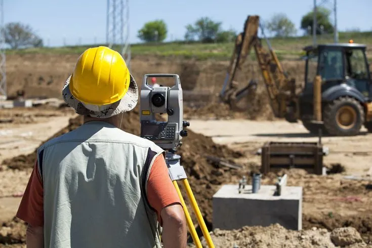
The key responsibility of any licensed surveyor is to determine the measurements accurately. The boundaries and characteristics of land parcels should also be evaluated. That includes conducting surveys with the help of specialized equipment like total stations, GPS receivers, and laser levels. The data gathered from these surveys will be used for multiple purposes, like the following:
● Boundary Establishment: One of the basic tasks of a licensed surveyor is to establish and ensure the boundaries of property. This includes retracing historical property boundary lines, which resolves disputes over boundaries and creates legal issues regarding land parcels. These boundaries define the ownership of property, zoning regulations, and use of the land.
● Land Subdivision: In the process of construction, licensed surveyors play a crucial role by subdividing larger areas of land into smaller parcels. This includes dividing the land as per the requirements of regulations and procedures that make sure that each portion of land owned by any owner or government meets the essential size, shape, and access conditions. Subdivision surveys are important for property developments, municipalities, and all transactions in real estate.
● Topographic Mapping: Their work goes beyond defining boundaries for a property; their skilled work goes beyond creating detailed topographic maps. These maps show the natural and man-made features of the landscape, which involve elevation changes, water bodies, roads, and structures. Topographic maps are important for planning a site, engineering the designs, and conducting environmental assessments.
● Construction Layout: During the construction phase of projects, licensed surveyors offer their support by precisely marking the locations and elevations of proposed structures, roads, utilities, and other improvements. This makes sure that the construction moves as per the approved plans and specifications, which reduces errors and cost-consuming rework.
● Geodetic Surveys: In addition to this, licensed surveyors may also conduct geodetic surveys to create control points and reference networks in large geographic areas. These surveys take part in accurate mapping, navigation, and geospatial analysis by using some supporting tools like GPS technology, aerial photogrammetry, and geographic information systems (GIS).
Challenges and Innovations in Surveying
When the core principles of surveying remain unmodified, this work has undergone major evolution through advancements in technology and alterations to regulatory frameworks. Licensed surveyors should adapt to emerging trends and overcome many challenges, which include:
● Technological Advancements: The arrival of advanced surveying tools and equipment, like unmanned aerial vehicles (UAVs), LiDAR scanners, and digital mapping software, has revolutionized the field of surveying. Licensed surveyors should stay ahead of these technological advancements and continuously upgrade their skills to stay competitive.
● Regulatory Compliance: Surveying practices are always subjected to strict regulatory standards and needs that are imposed by government agencies and professional communities. Licensed surveyors should make sure that they comply with surveying laws, property statutes, and ethical codes of conduct to maintain their licensure and uphold public trust.
● Environmental Considerations: With growing concerns about the sustainability of the environment and the management of natural resources, surveyors are more called upon to assess and reduce the environmental impact of land development projects. This may include conducting wetland delineations, habitat assessments, and ecological surveys to reduce any bad effects on ecosystems.
● Interdisciplinary Collaboration: Surveying is fundamentally interdisciplinary and requires collaboration with architects, engineers, urban planners, and other professionals that are involved in the construction environment. Surveyors should possess effective communication and teamwork skills to effectively coordinate with project stakeholders and ensure the seamless integration of survey data into the overall design and planning process of the construction.
Conclusion
To conclude, the work of a licensed surveyor is important in shaping the physical landscape and providing sustainable development for a city. From establishing boundaries of properties to creating detailed topographic maps, these surveyors play a versatile role in many industries that contribute to infrastructure projects, initiatives of land management, and efforts of environmental conservation. As technology continues to advance and regulatory procedures and needs evolve, licensed surveyors should be adaptable, innovative, and committed to holding the highest standards of professionalism and accuracy in their field. Whether it is delineating the lines of boundary or charting the contours of the land, the work of a licensed surveyor lays the groundwork for progress and prosperity in communities around the world.